TUSCALOOSA, Ala. — A unique radar developed by engineering researchers at The University of Alabama helped find the location to recover some of the oldest ice buried in Antarctica as part of an international effort to better understand the Earth’s climate history.
Using information collected by the radar, scientists leading the project confirmed the site where they intend to drill a core of ice in East Antarctica, located at Little Dome C, an area of about six square miles nearly 620 miles inland. It is possible the drilling will recover ice nearly 1.5 million years old, which may reveal why the climate cycle for the Earth’s ice ages lengthened roughly 1 million years ago.
“With active participation of UA students, our team developed very complex, high-sensitivity remote sensing radars in less than a year and successfully mapped deep layers no other group has been able to accomplish,” said Dr. Siva Prasad Gogineni, Cudworth Professor of Engineering, director of the UA Remote Sensing Center, and an internationally recognized expert in the field of remote sensing.
Dr. Stephen Yan, assistant professor of electrical and computer engineering, led the project for UA.
The work is part of Beyond EPICA, a more than $12 million project supported by the European Union involving 12 institutions in 10 European countries and with UA selected to perform precise radar imaging. It follows a previous effort, dubbed EPICA, which recovered an 800,000-year-old ice core.
Scientists, led by Dr. Carlo Barbante from Ca’ Foscari University of Venice and the Institute of Polar Sciences of the National Research Council of Italy, hope ice layered 1.5 million years ago can reveal Antarctica’s climate and the greenhouse gasses present during the Middle Pleistocene Transition, which happened between 900,000 and 1.2 million years ago.
During this time, the periods between glacial climates transitioned, lengthening from about 41,000 years to 100,000 years between ice ages. This change is the mystery Beyond EPICA seeks to resolve.
Little Dome C, nearly 25 miles from the nearest research station in an area administered by the French and Italian polar agencies, was selected as the potential site to recover the ancient ice after an initial two-year Radar Echo Sounding survey that covered more than nearly 2,500 miles of airborne and ground-based measurements as part of the previous EU project.
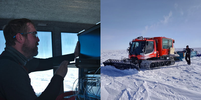
In November, UA’s radar was deployed to the site to scan nearly 2 miles below the ice to precisely select the exact drilling site. The work was conducted by Dr. Drew Taylor, UA assistant professor of electrical and computer engineering, with international collaborators Dr. Daniel Steinhage from the Alfred Wegener Institute in Germany and Dr. David Lilien from the University of Copenhagen in Denmark.
The ultra-wideband radar and antenna capable of penetrating deep into ice was able to image, with high definition, the ice layering in the deepest part of the ice sheet. The radar was designed and fabricated by UA researchers, including seven graduate and eight undergraduate students in the UA College of Engineering, and led by Dr. Charles O’Neill from the UA Remote Sensing Center.
Radar development was supported by the University of Copenhagen, the Alfred Wegener Institute, the National Science Foundation and UA.
The radar was previously used in Greenland as part of another international effort to unveil ancient climate history and to provide perspectives on improving climate models.
“We’re proving we have the expertise in remote sensing with our radar systems and design to provide unique solutions to answer the questions the scientists have about the ice and our climate,” Taylor said.
Taylor and the team at Little Dome C drove a tightly spaced grid over two areas about 2.5 square miles in size. The radar collected a tremendous amount of data initially analyzed on-site using software developed by students and faculty from UA.
“It became apparent to everyone these data were much improved from anything seen before in this area,” Taylor said. “It is a testament to the effort put forth by the leadership, faculty, staff and students of the Remote Sensing Center over the past weeks and months.”
The data was further analyzed and modelled in European laboratories, allowing scientist to confirm with a meter-scale resolution the exact future drilling site. The radar imaging showed there should not be any ice melting at the base, despite the tremendous pressure of the mass of ice above it. The characteristics of the deeper layers, with ice at least 1.5 million years old, should be preserved with a good temporal resolution, the scientist believe.
“It is the first time that a site for deep drilling has been selected with such a high precision and effort,” said Dr. Olaf Eisen with the Alfred Wegener Institute and one of the leaders of the Beyond EPICA project. “The new radar measurement showed more clearly than before, that the ice there is well stratified and most probably very old.”
If the project proceeds according to plan, it will take six years to drill, collect and analyze the ice from what will be a deep hole.
(This story originally appeared on The University of Alabama’s News Center website)