ACTIVE DAY: Some rain is falling across the northwest corner of Alabama early this morning… the rain is more widespread to the north over western and middle Tennessee. Showers and storms are likely over North Alabama by mid to late afternoon… they will drop southward into the central counties of the state early tonight.
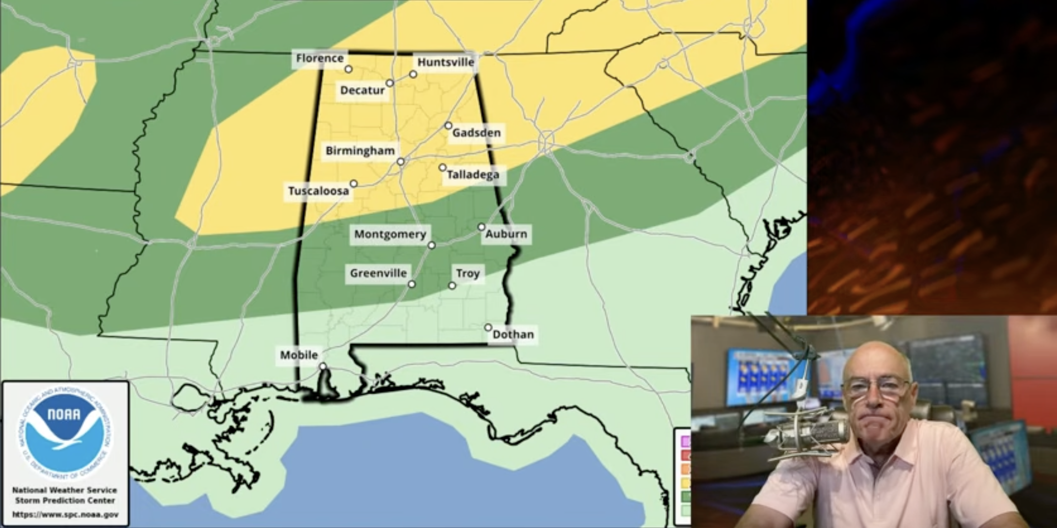
SPC has defined a level 2/5 risk of severe storms for roughly the northern half of Alabama, and level 1/5 risk extends as far south as Chatom, Georgiana, Troy, and Eufaula.

The main window for strong to severe storms will come from 3:00 p.m. until midnight, and the primary threat will come from strong winds. Keep in mind with saturated soil conditions, even 40-50 mph gusts (sub-severe) can bring down some trees. Tornadoes are very rare in Alabama in summer unless a tropical system is involved, but we note SPC has low tornado probabilities defined for North Alabama. The risk of a tornado is very low, but not zero with a surface boundary around. We will watch radar trends closely.
REST OF THE WEEK: High resolution models suggest tomorrow will be drier with only a few isolated showers around. Then, fairly typical summer weather is the story Wednesday through Friday with the usual risk of random, scattered, mostly afternoon and evening showers and storms around. Afternoon highs will be in the 85-90 degree range.
THE WEEKEND: An upper ridge will begin to build across the Deep South, meaning the weather will be hotter and drier. Afternoon highs over the weekend will be in the low 90s in most places, and showers will be few and far between. The ridge will likely hold through much of next week, with afternoon temperatures possibly reaching the mid 90s. The ridge will keep the weather drier with only isolated showers. See the video briefing for maps, graphics, and more details.

TROPICS: All is quiet across the Atlantic basin; tropical storm formation is not expected for at least the next seven days.
ON THIS DATE IN 1972: Hurricane Agnes deluged Pennsylvania and New York State with torrential rains resulting in the most costly flood in U.S. history. In the Middle Susquehanna Valley of Pennsylvania, 24 hour rainfall amounts were generally 8 to 12 inches, with up to 19 inches in extreme southwestern Schuylkill County. At Wilkes-Barre, PA, the dike was breached destroying much of the town. Flooding resulted in 117 deaths.
Look for the next video briefing here by 3:00 this afternoon… enjoy the day!
For more weather news and information from James Spann and his team, visit the Alabama Weather Network.