QUIET AFTERNOON: Showers are very isolated across Alabama today. The sky is partly sunny, and temperatures are mostly in the upper 80s and low 90s. We do note a big flooding event unfolded this morning over northwest Alabama; parts of Franklin County had more than 6 inches of rain, and a flash flood emergency was issued by National Weather Service Huntsville for a while. That large rain mass diminished and drifted into Tennessee later in the morning.
The weather won’t change much Thursday. It will be partly sunny, hot and humid with a few scattered showers or storms by afternoon. Temperatures reach the low 90s in most places, and the big wind/rain impact from Hurricane Laura will be west of Alabama.
FRIDAY AND THE WEEKEND: Laura will turn to the right over Arkansas and pass north of Alabama Friday. This position could set the stage for a low-end risk of a few isolated tornadoes over the northwest part of the state Friday afternoon and evening. Otherwise, Friday will feature more clouds than sun with scattered to numerous showers and thunderstorms. The high will be in the mid to upper 80s.
A very moist, tropical air mass will stay in place over Alabama Saturday and Sunday; a few showers and thunderstorms are likely both days with highs between 86 and 90 degrees. It won’t be a total washout, but be ready for rain at times if you have something planned outdoors. Most but not all of the rain will come in the window from noon to midnight.
NEXT WEEK: The tropical air stays in place. Each day we will have to mention scattered showers and thunderstorms, mostly during the afternoon and evening hours. A very cool air mass will drop down into the northern states next week, but it won’t have enough southward push to reach Alabama.
LAURA: Extremely dangerous Hurricane Laura will make landfall tonight near the Texas/Louisiana border with sustained winds of 145 mph and a 15- to 20-foot storm surge east of the center.
Key messages from the National Hurricane Center:
- Unsurvivable storm surge with large and destructive waves will cause catastrophic damage from Sea Rim State Park, Texas, to Intracoastal City, Louisiana, including Calcasieu and Sabine Lakes. This surge could penetrate up to 30 miles inland from the immediate coastline. Only a few hours remain to protect life and property, and all actions should be rushed to completion.
- Hurricane-force winds are expected tonight in portions of the Hurricane Warning area from San Luis Pass, Texas, to west of Morgan City, Louisiana, with catastrophic wind damage expected where Laura’s eyewall makes landfall. Hurricane-force winds and widespread damaging wind gusts will spread well inland across portions of eastern Texas and western Louisiana early Thursday.
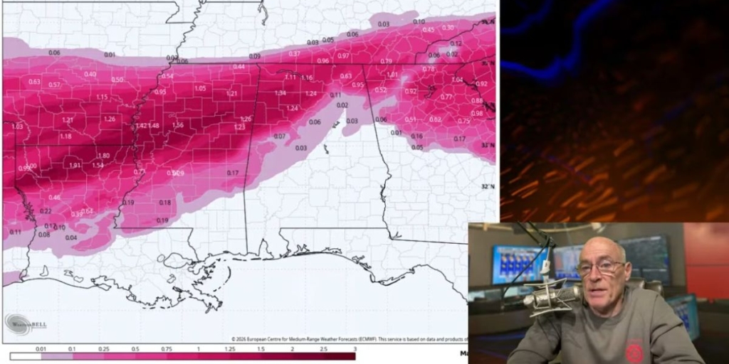
- Widespread flash flooding along small streams, urban areas and roadways is expected to begin this afternoon into Thursday from far eastern Texas across Louisiana and Arkansas. This will also lead to minor to isolated moderate freshwater river flooding. The heavy rainfall threat and localized flash and urban flooding potential will spread northeastward into the middle Mississippi, lower Ohio and Tennessee Valleys Friday night and Saturday.
CENTRAL GULF COAST: Dangerous rip currents will continue along the coast from Gulf Shores over to Panama City Beach through Friday, but there will be little direct weather impact other than a stiff south breeze and tropical showers from time to time. There will be a pretty decent amount of sun each day along the central Gulf Coast.
ON THIS DATE IN 1992: Hurricane Andrew made a second landfall near Burns Point, Louisiana, as a Category 3 hurricane. Morgan City, Louisiana, recorded sustained winds of 92 mph with a peak gust of 108 mph. Hammond, Louisiana, was deluged with 11.92 inches of rain. As Andrew moved inland and weakened, it spawned 47 tornadoes from this date through Aug. 28 from the South to the Mid-Atlantic States.
BEACH FORECAST: Click here to see the AlabamaWx Beach Forecast Center page.
WEATHER BRAINS: You can listen to our weekly 90-minute show anytime on your favorite podcast app. This is the show all about weather featuring many familiar voices, including the meteorologists at ABC 33/40.
CONNECT: You can find me on the major social networks:
Facebook
Twitter
Instagram
Pinterest
Snapchat: spannwx
For more weather news and information from James Spann and his team, visit AlabamaWx.
(Courtesy of Alabama NewsCenter)