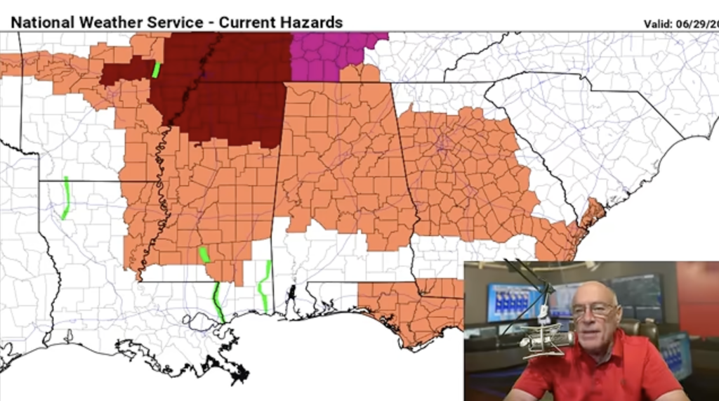
RADAR CHECK: Rain has been fairly widespread over the northern half of the state today; a flash flood warning was required for a while for Sumter County in west Alabama. With a cloudy sky, temperatures are mostly in the 70s over the northern and central counties. But south Alabama is seeing a pretty good supply of sunshine with temperatures between 85 and 90 degrees. The rain today is partly associated with the remnants of former Tropical Storm Marco, although the core circulation is far to the west off the Louisiana coast. Rain tapers off tonight.
Wednesday will be brighter and warmer; the sky will be partly sunny with a high between 87 and 90 degrees. Scattered showers are possible, but the rain won’t be as widespread as today.
THURSDAY/FRIDAY: The circulation of Hurricane Laura will be moving through Louisiana and Arkansas, well to the west of Alabama, on Thursday. Again we expect a partly sunny sky with temperatures reaching the low 90s. While much of the day will be dry, a few scattered storms will likely form by mid to late afternoon. For now it looks like the best chance of tornado activity will be west of Alabama. Then, on Friday, showers and storms become more likely as deep tropical moisture is pulled into the state. A low-end risk of a brief tornado could develop over the northwest part of the state as the remnant circulation of Laura turns to the east. Friday won’t be a washout, but occasional tropical showers are likely.
THE ALABAMA WEEKEND: High precipitable water values will remain in place; look for scattered to numerous showers and thunderstorms Saturday and Sunday. The sky will be occasionally cloudy with highs in the mid to upper 80s. Most, but not necessarily all, of the showers will come in the window from noon to midnight both days.
NEXT WEEK: Deep tropical moisture stays in place; there will be some risk of showers and storms daily through the week. A nice surge of cool, crisp air will move down into the northern states, but for now it doesn’t look like it will have enough southward push to reach Alabama.
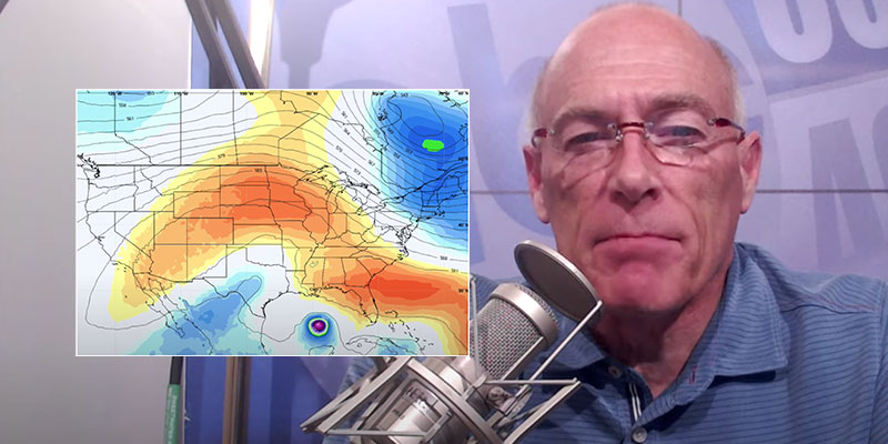
HURRICANE LAURA: Laura is about 500 miles southeast of Lake Charles, Louisiana, this afternoon with winds of 75 mph. It is moving to the north/northwest at 16 mph. The National Hurricane Center still expects Laura to become a major, dangerous Category 3 hurricane Wednesday night at the time of landfall, forecast to be around the Sabine Pass (the Texas/Louisiana border).
Key messages from the NHC:
- Laura is forecast to reach the northwestern Gulf Coast at or near major hurricane intensity Wednesday night. Do not focus on the details of the official forecast given the typical uncertainty in the NHC’s track and intensity predictions. Storm surge, wind and rainfall hazards will extend well away from Laura’s center along the Gulf Coast.
- There is the danger of life-threatening storm surge accompanied by large and dangerous waves from San Luis Pass, Texas, to the mouth of the Mississippi River, including areas inside the Port Arthur Hurricane Flood Protection system. A Storm Surge Warning is in effect and residents should follow any advice given by local officials. Actions to protect life and property should be rushed to completion today, as water levels will begin to rise Wednesday.
- Hurricane conditions are expected by Wednesday evening in the area from San Luis Pass, Texas, to west of Morgan City, Louisiana, and a Hurricane Warning is in effect. Tropical storm conditions are expected to begin in the warning area Wednesday afternoon.
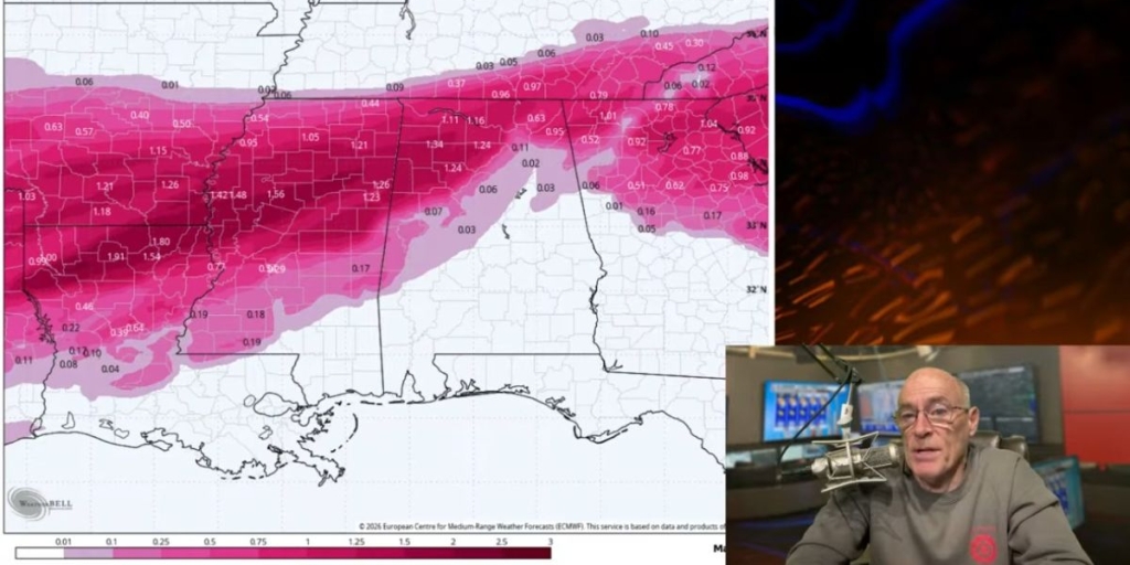
- The threat of widespread flash and urban flooding along with small streams overflowing their banks will increase Wednesday night into Thursday from far eastern Texas across Louisiana and Arkansas. This will also lead to minor to isolated moderate river flooding. The heavy rainfall threat will spread northeastward into the middle Mississippi, lower Ohio and Tennessee Valleys Friday and Saturday.
CENTRAL GULF COAST: Laura will make landfall 450-500 miles west of Dauphin Island, Gulf Shores, Destin and Panama City Beach. There will be little direct weather impact other than a stiff south breeze and occasional tropical showers. You will see a decent amount of sun each day through the rest of the week, but dangerous rip currents are likely through Friday. If you see red or double red flags, do not get in the water.
The good news is that the rest of the Atlantic basin, for now, is very quiet.
ON THIS DATE IN 2017: Hurricane Harvey, a devastating Category 4 hurricane, made landfall, causing catastrophic flooding and many deaths. It is tied with 2005’s Hurricane Katrina as the costliest tropical cyclone on record, inflicting $125 billion in damage, primarily from catastrophic rainfall-triggered flooding in the Houston metropolitan area and southeast Texas. It was the first major hurricane to make landfall in the United States since Wilma in 2005, ending a record 12-year span in which no hurricanes made landfall at the intensity of a major hurricane throughout the country. In a four-day period, many areas received more than 40 inches of rain as the system slowly meandered over eastern Texas and adjacent waters, causing unprecedented flooding.
BEACH FORECAST: Click here to see the AlabamaWx Beach Forecast Center page.
WEATHER BRAINS: You can listen to our weekly 90-minute show anytime on your favorite podcast app. This is the show all about weather featuring many familiar voices, including the meteorologists at ABC 33/40.
CONNECT: You can find me on the major social networks:
Facebook
Twitter
Instagram
Pinterest
Snapchat: spannwx
For more weather news and information from James Spann and his team, visit AlabamaWx.
(Courtesy of Alabama NewsCenter)