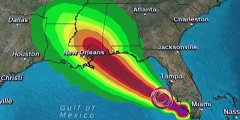
Tropical Storm Gordon is continuing to strengthen and is expected to become a hurricane late Tuesday when it hits the central U.S. Gulf Coast, including coastal Mississippi.
From there, it is forecast to move inland over the lower Mississippi Valley on Wednesday.Gordon formed into a tropical storm near the Florida Keys early Monday as it lashed the southern part of the state with heavy rains and high winds.
The storm was centered 280 miles (450 kilometers) east-southeast of the mouth of the Mississippi River, forecasters said early Tuesday morning. Maximum sustained winds were clocked at 65 mph (100 kph).
A hurricane warning was put into effect for the area stretching from the mouth of the Pearl River in Mississippi to the Alabama-Florida border.
As much as 8 inches (20 centimeters) of rain could fall in some parts of the Gulf states through late Thursday.
The Miami-based center said the storm is also expected to bring “life-threatening” storm surge to portions of the central Gulf Coast.
A storm surge warning has been issued for the area stretching from Shell Beach, Louisiana, to Dauphin Island, Alabama.
The warning means there is danger of life-threatening inundation. The region could see rising waters of 3 to 5 feet (0.9 to 1.5 meters).
“The deepest water will occur along the immediate coast near and to the east of the landfall location, where the surge will be accompanied by large waves,” the center said.
Louisiana Gov. John Bel Edwards declared a state of emergency Monday and said 200 National Guard troops will be deployed to southeastern Louisiana.
The storm’s predicted track had shifted slightly east as of Monday evening, meaning Louisiana is currently just outside the area under the hurricane warning.
Still, the southeastern part of the state remains under a tropical storm warning and residents need to be prepared for the storm to shift west, Edwards said.
“This storm has every possibility to track further in our direction,” Edwards said during a news conference Monday evening.
New Orleans Mayor LaToya Cantrell held an afternoon news conference and said the city has “the pumps and the power” needed to protect residents.
But authorities issued a voluntary evacuation order for areas outside the city’s levee protection system, including the Venetian Isles, Lake Saint Catherine and Irish Bayou areas.
Cantrell urged residents within the levee protection area to stock up on supplies and shelter in place.
Miami Beach Police said via Twitter that the Labor Day holiday was “NOT a beach day,” with rough surf and potential rip currents.
Red flags flew over Pensacola-area beaches in Florida’s Panhandle, where swimming and wading in the Gulf of Mexico was prohibited.
More than 4,000 Florida Power & Light customers lost power Monday due to weather conditions.
The National Weather Service said conditions were “possible” for tornadoes in the affected parts of South Florida on Monday night.
The storm left many businesses on Florida’s Gulf Coast feeling shortchanged by the holiday weekend.
The area has already been heavily impacted by this summer’s so-called “red tide”— massive algae blooms that have caused waves of dead marine life to wash up along the coast.
Jenna Wright, owner of a coffee shop in Naples, Florida, told the Naples Daily News that she had expected higher numbers for the Labor Day weekend.
“This is normally a decent weekend, but the storm and red tide aren’t helping,” Wright said.
“We’re a beach coffee shop, and if people can’t go to the beach, then we won’t get any customers.”
Separately, Tropical Storm Florence continues to hold steady over the eastern Atlantic.
Forecasters say little change in strength is expected in coming days and no coastal watches or warnings are in effect.
(Associated Press, copyright 2018)
Sign-up now for our daily newsletter and never miss another article from Yellowhammer News.


