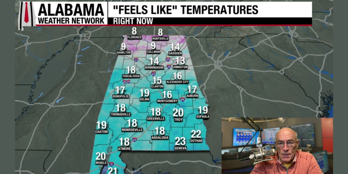
FRIGID START: Here are some temperatures across Alabama just before sunrise:
Cullman 12
New Market 12
Decatur 13
Jasper 13
Meridianville 13
Haleyville 14
Huntsville 15
Fort Payne 15
Albertville 16
Birmingham 16
Gadsden 16
Hueytown 16
Muscle Shoals 17
Pell City 18
Talladega 18
Scottsboro 18
Anniston 19
Tuscaloosa 19
Demopolis 21
Alexander City 21
Auburn 22
Montgomery 23
Greenville 23
Troy 23
Eufaula 25
Andalusia 25
Enterprise 26
Dothan 26
Mobile 26
Gulf Shores 28
With sunshine in full supply today, temperatures rise into the upper 30s across the Tennessee Valley, with 40s for the rest of the state. The warm-up continues through mid-week; we reach the 50s tomorrow, and by Wednesday the southern half of the state will see highs in the 60s.
Clouds will increase Wednesday night, and rain will move into the state Thursday and Thursday night ahead of a cold front. Rain amounts will be generally 1/2 inch or less.
Friday will be mostly sunny and cooler with highs generally in the 50s.
THE ALABAMA WEEKEND: Saturday will be dry and pleasant with a high in the 57-67 degree range. Moisture levels rise Sunday, and a few scattered showers are possible with a high in the 60s.
CHRISTMAS WEEK: Global models continue to suggest much of the contiguous U.S. will experience above average temperatures; for Alabama on most days highs will be in the 60s and lows in the 40s and low 50s. For now not seeing any major rain event through the week.

FOOTBALL WEATHER: Alabama will be in Norman to take on Oklahoma in the first round of the college football playoffs (7 p.m. kickoff) … the sky will be clear with temperatures falling from the mid 50s at kickoff, to near 50 by the final whistle. It will be a bit breezy with a south wind averaging 10-20 mph.
ON THIS DATE IN 1992: Cyclone John hit the sparsely populated northwest coast of Australia with winds gusting to 185 mph. John was the strongest cyclone to hit Australia in over 100 years.
For more weather news and information from James Spann and his team, visit the Alabama Weather Network.