ACTIVE PATTERN: Alabama’s weather will be active this week, which is to be expected in mid-March. The first round of storms will come later today and tonight; SPC has a “slight risk” (level 2/5) of severe thunderstorms defined for parts of Central and West Alabama, with a “marginal risk” (level 1/5) for most of the rest of the state.

The main risk of strong/severe storms will come from about 4:00 until 10:00 p.m… storms will slowly weaken late tonight. With this round of thunderstorms the primary threat will come from large hail thanks to steep lapse rates. Strong, gusty winds are likely with the heaver storms… the tornado threat is low, but not zero. Before the rain arrives temperatures will reach the 77-83 degree range this afternoon.
Tomorrow will be mostly dry with only isolated showers… expect a high between 77 and 84 degrees for most places.
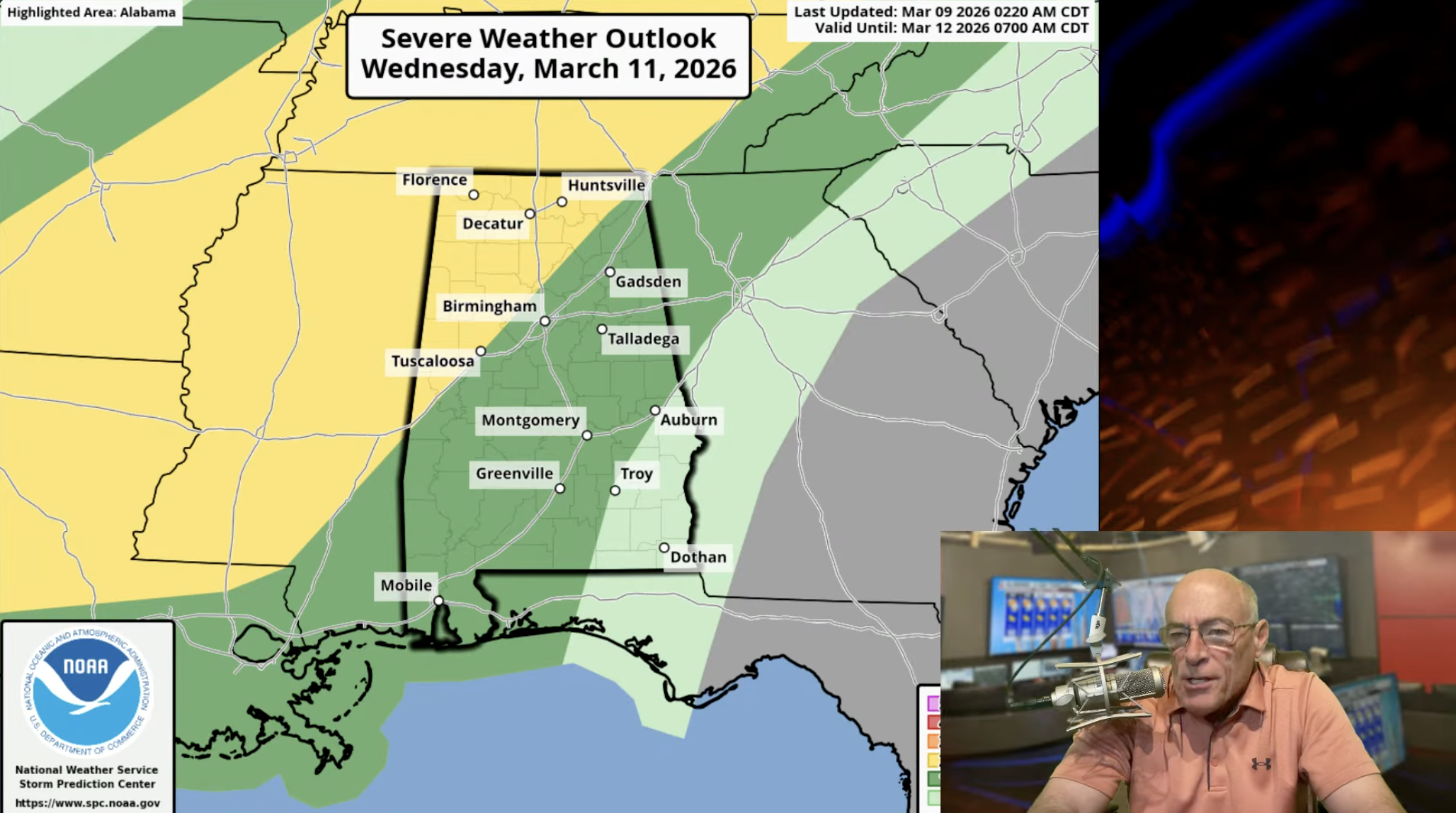
WEDNESDAY/THURSDAY: Wednesday will be warm and breezy with highs at or over 80 degrees for most communities. A cold front will push a line of thunderstorms into the state Wednesday night, and those storms could be strong to severe. SPC has defined a “slight risk” (level 2/5) north of a line from Tuscaloosa to Scottsboro; a “marginal risk” is in place for the rest of Alabama except for the southeast counties, where no severe storms are expected.

The primary threat Wednesday night will come from strong, potentially damaging straight line winds. An isolated tornado or two can’t be ruled out. Greatest risk of severe storms will come from about 6:00 p.m. Wednesday through 2:00 a.m. Thursday. Rain amounts for most of Alabama will be in the 1-3 inch range between now and early Thursday morning.
Rain will end Thursday morning across South Alabama, followed by clearing sky. The day will be much cooler with highs only in the upper 50s across the Tennessee Valley. Temperatures will reach the mid to upper 30s over the northern third of the state by daybreak Friday with a clear sky; some frost will be possible. Friday will be a sunny day with highs generally in the 70s.
THE WEEKEND: Saturday will be a beautiful day; sunshine in full supply with a high between 75 and 85 degrees. Sunday looks mostly dry; a cold front will bring some risk of showers late in the day and Sunday night. Moisture will be very limited with this front.
Another shot of colder air arrives early next week; most frost is likely for North Alabama by Tuesday, Wednesday, and Thursday morning. At this time most of the week looks dry… See the video briefing for maps, graphics, and more details.

ON THIS DATE IN 1964: A F3 tornado moved through western Lauderdale County. A concrete block cafe was demolished along U.S. 72. In the Whitehead community, two homes were totally destroyed killing a person in each one. Several other homes and automobiles were damaged. Trees and power lines were downed along the path.
ON THIS DATE IN 2011: An EF-2 tornado moved through Theodore, in Mobile County. Several businesses were damaged, and there were a few minor injuries.
For more weather news and information from James Spann and his team, visit the Alabama Weather Network.