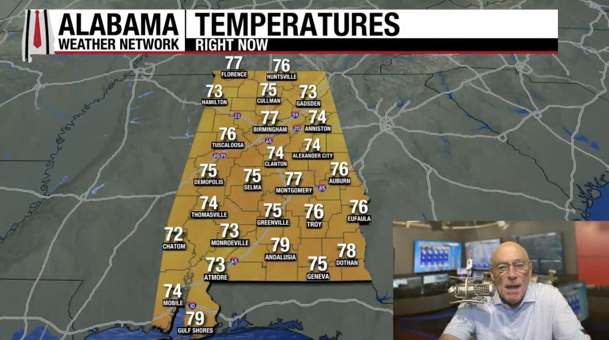
HOT: Summer heat finally returns to Alabama over the next five days with highs in the low to mid 90s for most places. As always on a summer day, a few pop-up storms are likely during the afternoon and evening hours (mainly from noon to midnight)… but they should be widely scattered. The chance of any one specific location seeing rain today is 30-40 percent, dropping to 20-25 percent over the weekend.
The upper ridge over the region will weaken late next week, which will open the door for an increase in the number of showers and thunderstorms and lower heat levels. Highs will be in the upper 80s for many areas by Friday and the following weekend (August 22-24)… See the video briefing for maps, graphics, and more details.

TROPICS: Erin will likely become a hurricane in the Atlantic later this morning; early this morning winds are 70 mph. The system is about 570 miles north of the northern Leeward Islands, and is moving to the west/northwest at 17 mph.
There is no change in the forecast track. Erin will pass north of the Leeward Islands and Puerto Rico, then turning north, east of the Bahamas. Next week the system will accelerate northeast over the open Atlantic; no threat to the U.S. It could be close to Bermuda in 5-6 days.


There is one other area of interest… recent satellite wind data indicate that the disturbance located over the western Gulf (Invest 98L) continues to lack a closed low-level circulation. However, shower activity has increased some over the past few hours and the system could become a short-lived tropical depression before it moves inland over northeastern Mexico or southern Texas this afternoon or evening. Regardless of development, locally heavy rainfall is possible along portions of northeastern Mexico and southern Texas over the next couple of days, and interests there should monitor the progress of this system. Another Air Force Reserve Hurricane Hunter aircraft is scheduled to investigate the system later this morning.
No tropical storms or hurricanes are expected across the Gulf for at least the next seven days.
ON THIS DATE IN 1787: Tornadoes were reported in Connecticut, Rhode Island, Massachusetts, and New Hampshire. Wethersfield, Connecticut was hard hit by the tornado outbreak. There, a woman and her family were caught in the open. She and her son were killed. Clothes from the family farm were carried three miles away. This event is regarded to be the most significant tornado outbreak in early New England history.
ON THIS DATE IN 1969: The National Hurricane Center issued a hurricane watch for a 110 miles stretch of land in Florida, between Apalachicola and Fort Walton Beach, as Hurricane Camille continued to strengthen over the Gulf. Watches would be later extended westward, and landfall would come on the Mississippi coast August 17 at category five strength.
Courtesy of Alabama Weather Network.