RAIN ARRIVES LATER TODAY: Clouds will increase across Alabama today ahead of a surface front, and rain will move into the western counties this afternoon; expect a high this afternoon in the 53-63 degree range. We expect a few periods of rain tomorrow and Friday; highs will be in the 50s.
WEEKEND WINTER STORM THREAT: A winter storm watch has been issued for the northern third of Alabama for the weekend. The watch is for areas along and north of a line from Millport to Fayette to Jasper to Oneonta to Gadsden to Spring Garden. For now the watch does not include Tuscaloosa, Birmingham, Anniston, or points south.

Here are the key messages this morning…
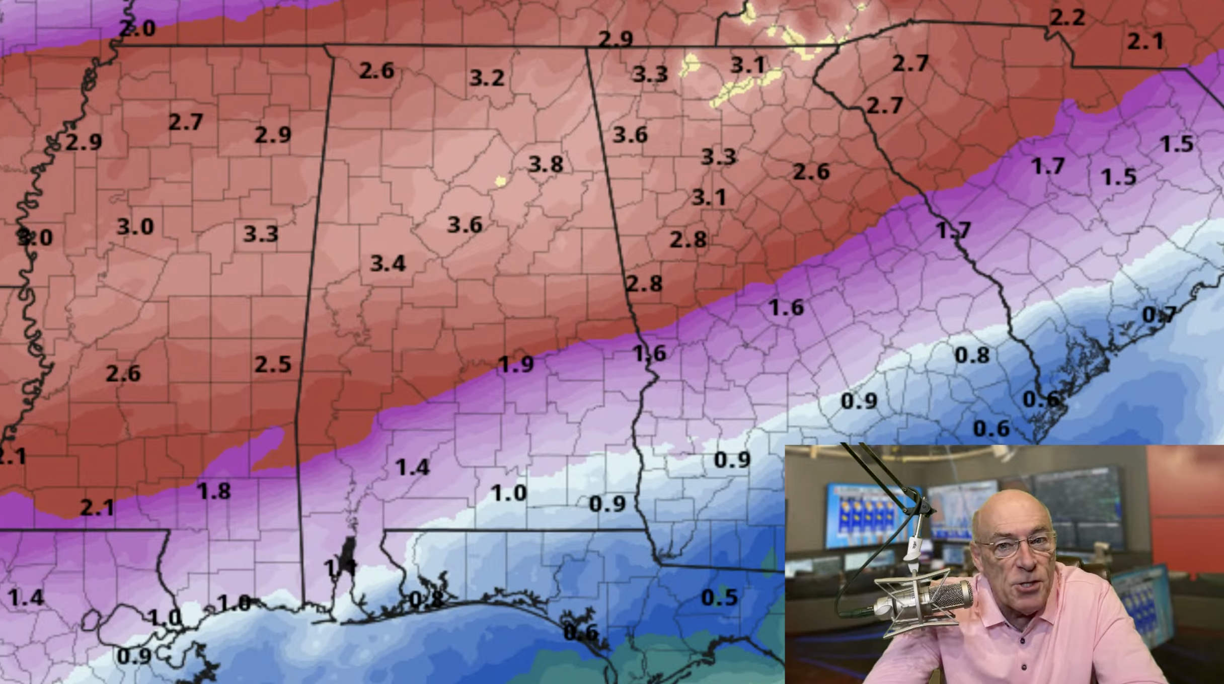
*New model output has shown a northward shift in the projected path of the surface low. Originally the low was forecast to move through the northern Gulf; now most guidance shows the low moving through southern parts of Mississippi and Alabama. Accordingly, the highest risk of winter weather impact has shifted to the north as well. This is the reason the I-20 corridor (Tuscaloosa, Birmingham, Anniston) was not included in the winter storm watch.
*This is why we have been holding off on making an impact forecast until tomorrow. Models could shift southward again, and there is considerable uncertainty. We need to get within 60 hours of an event to make a forecast about specific impact.
*With northward shift, the risk of significant snow accumulation has decreased for the Tennessee Valley; the greater concern there is now ice accumulation from freezing rain.
*The greatest risk of ice accumulation is in the winter storm watch area, where there could be significant travel impact and potential for some power outages.
*Freezing rain could begin across parts of North Alabama as early as 5-6 a.m. Saturday.
*Precipitation will continue through the weekend statewide; it will be just rain for the southern 2/3 of the state. The reliable European global models suggests the Tennessee Valley could rise above freezing Sunday with a cold rain; this would ease icing issues if it happens.
*There is a chance the rain could change back to freezing rain or snow Sunday night before ending across North Alabama. Temperatures will drop quickly, and lows will be in the teens over the northern half of the state by Monday morning. With so much rain expected over the weekend, black ice issues are a very real possibility Monday morning as far south as U.S. 80.
*Temperatures could reach the single digits across parts of North Alabama by Tuesday morning.
*I continue to receive many messages about travel this weekend. I possess no knowledge or skill about future road conditions, and can’t give specific advice. It depends on your risk tolerance, and your ability to drive on wet/icy roads. Highest risk of icy travel is in the winter storm watch area, and we will have the impact forecast tomorrow.
See the video briefing for maps, graphics, and more details.

ON THIS DATE IN 2025: A generational winter storm brought heavy snow to the Gulf Coast and southern parts of Alabama. Mobile Regional Airport set a new 2-day snowfall record with an impressive 7.5 inches of measured snow. This surpassed the previous 2-day snowfall record of 6.0 inches of snow, which had stood since the February Snowstorm of 1895. Pensacola shattered its previous 2-day snowfall record with an incredible 8.9 inches of measured snow. This far surpassed the prior 2-day record of 3.0 inches of snow, set during the February Snowstorm of 1895.
Look for the next video briefing here by 3:00 this afternoon… enjoy the day!
For more weather news and information from James Spann and his team, visit the Alabama Weather Network.