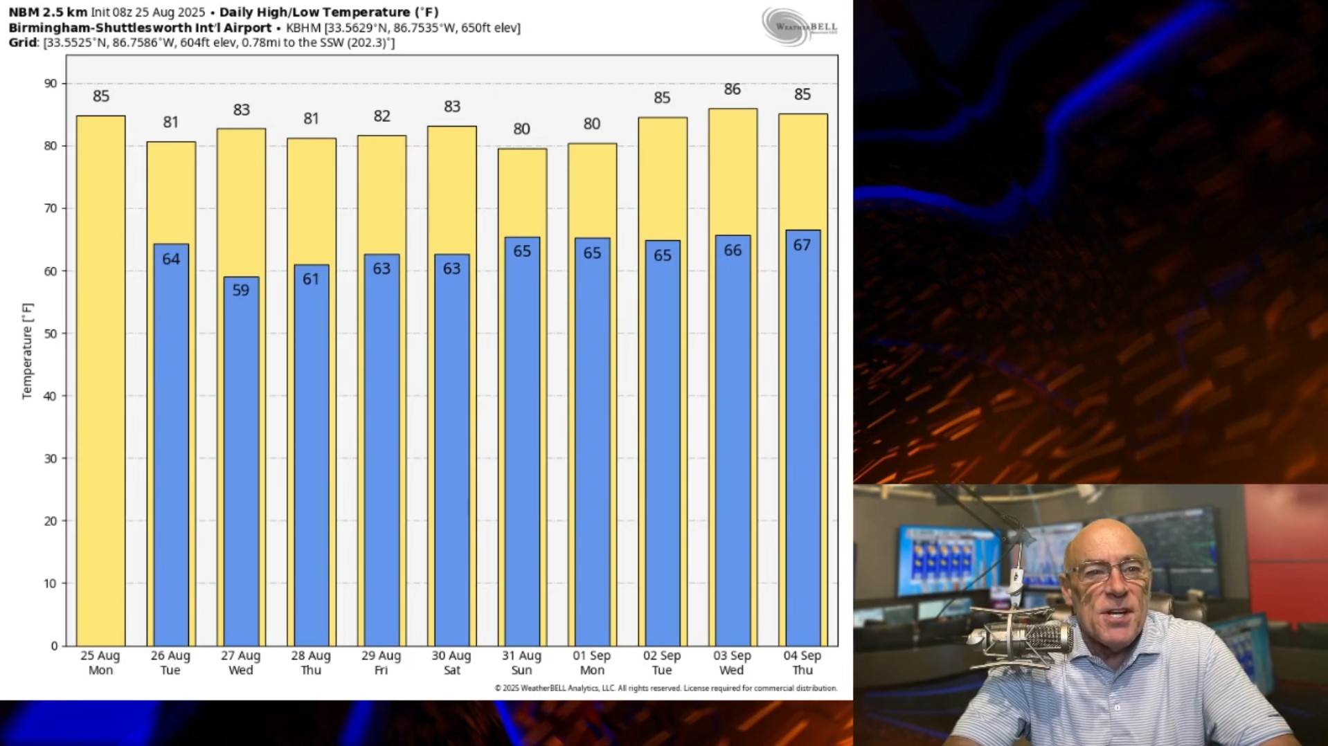
FALL PATTERN: We all know we can have scorching heat in Alabama in late August, but that won’t be the case this year thanks to a fall-like upper air pattern over North America. A long wave upper trough is over the eastern part of the continent … this pushed a cold front through late yesterday, and will push another front through the state tomorrow. This means lower humidity levels across the Deep South, along with cooler nights.
The weather will be generally dry through Wednesday, although we will mention the chance of a few sprinkles tomorrow with the next front. Highs will be in the 78–84-degree range, and by early Wednesday most North Alabama communities will see a low in the mid to upper 50s for a nice preview of fall.
Global models are hinting at some moisture return Thursday and Friday ahead another surface front, along with some risk of showers. Rain amounts will likely be light and spotty.
THE ALABAMA WEEKEND: A surface front will likely become stationary over the region, meaning some risk of showers and a few thunderstorms Saturday and Sunday. Not a wash-out at all, but some rain is very possible from time to time. Highs will be mostly in the low to mid 80s.
Some risk of showers will likely continue into week with temperatures remaining below average.

TROPICS: Tropical Storm Fernand, in the Atlantic about 360 miles east/northeast of Bermuda, has sustained winds of 50 mph. The system is moving north/northeast at 20 mph, and will become post-tropical in the North Atlantic tomorrow night. It will stay far from land.

The only other area of interest is Invest 99L, near the Windward Islands. Showers and thunderstorms associated with this tropical wave have decreased over the past 24 hours, and recent satellite wind data indicate the winds associated with the system have also decreased. The disturbance is moving into a less favorable environment, and the chances of development are diminishing. Although the system is weakening, gusty winds are possible over the Windward Islands through this morning. Most models show this wave dissipating, and NHC gives it only a 10% chance of development.

No tropical storms or hurricanes are expected across the Gulf for at least the next 10 days.
FOOTBALL WEATHER: College football is back! It begins Thursday night when UAB hosts Alabama State at Protective Stadium in downtown Birmingham 7:30p CT kickoff). There is a small risk of a shower during the game … temperatures will fall from near 78 at kickoff into the low 70s by the fourth quarter.
Auburn will take on Baylor in Waco, Texas Friday night (7 p.m. kickoff) … the sky will be mostly cloudy and there is an outside risk of a passing shower during the game. Temperatures will fall from near 89 degrees at kickoff into the low 80s by the final whistle.
Saturday Alabama will be in Tallahassee to take on Florida State (2:30 p.m. kickoff) … the sky will be cloudy at times, and a few passing showers or storms are likely during the game. Temperatures will be in the mid 80s.
ON THIS DATE IN 2005: Katrina made its initial landfall along the southeast Florida coast as a Category 1 hurricane with 80 mph winds. From there it intensified rapidly and attained Category 5 status for a period of time as it moved northwest on August 28th. Katrina weakened to a Category 3 before making landfall along the northern Gulf Coast on August 29.
For more weather news and information from James Spann and his team, visit the Alabama Weather Network.