DRY DAY AHEAD: Most of Alabama will be rain-free today … with more clouds than sun we expect highs in the 60s and low 70s. Clouds will thicken late in the day, and rain will move back into state tonight ahead of a disturbance rotating around the upper low parked over the region.
Expect periods of rain tonight and tomorrow. Rain amounts will vary from near one inch across the Tennessee Valley to only one tenth of an inch across the southeast corner of the state. The air will be cool and stable; no thunder involved.
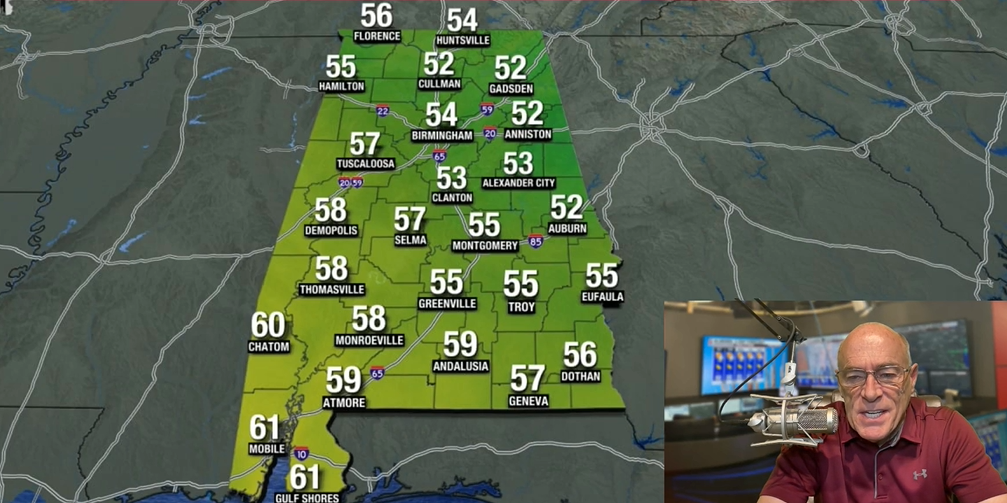
THURSDAY THROUGH THE WEEKEND: Expect partly to mostly sunny, cool days and fair chilly nights. Highs mostly in the 60s … North Alabama will drop into the 30s early Friday and Saturday morning with potential for some scattered light frost.
NEXT WEEK: Forecast confidence is not especially high early in the week; the reliable European global model suggests some risk of rain for the southern half of the state Monday and Tuesday, while the American GFS model is dry. For now the weather looks dry Wednesday through Friday … temperatures will be seasonal for early November with highs in the 60s and 70s.

TROPICS: Extremely dangerous Hurricane Melissa, with 175 mph sustained winds, has made the turn and is now moving north/northeast at 5 mph. It will move Jamaica later today, eastern Cuba tomorrow, and the Southeast Bahamas tomorrow night as the system accelerates to the northeast. Melissa could be close to Bermuda late Thursday night or early Friday as a weakening category one hurricane.

Catastrophic flash flooding, landslides, and destructive winds will continue through today across Jamaica, causing widespread infrastructure damage, power and communication outages, and isolated communities. Total structural failure is possible near the path of Melissa’s center. Along the southern coast, life-threatening storm surge and damaging waves are expected through the day.
The rest of the Atlantic basin is quiet. Melissa will stay well east of the U.S. … and no tropical storms or hurricanes are expected across the Gulf for at least the next 10 days.
FOOTBALL WEATHER: Auburn hosts Kentucky Saturday night at Jordan-Hare Stadium (6:30 p.m. kickoff). The sky will be mostly fair with temperatures falling from near 60 degrees at kickoff into the upper 40s by the final whistle.
TIME CHANGE: We go back on standard time this weekend. Clocks go back one hour late Saturday night; the sunset Sunday will come around 4:50 p.m. for most of Alabama.
ON THIS DATE IN 1999: A Super Typhoon, known as Cyclone 05B reached the equivalent of the Category 5 hurricane on this day. This storm is the strongest tropical cyclone ever record in the North Indian Ocean. Cyclone 05B hit the Indian State of Odisha near the city of Bhubaneswar on October 29. An estimated 10,000 individuals would die from this cyclone, and 1.67 million people were left homeless.
ON THIS DATE IN 2020: Hurricane Zeta made landfall at Cocodrie, Louisiana as a category three storm. In Alabama, Zeta produced widespread wind gusts over 40-50 mph with some with some locations experiencing gusts of 50-70 mph. Around one half million people in the state lost power.
For more weather news and information from James Spann and his team, visit the Alabama Weather Network.