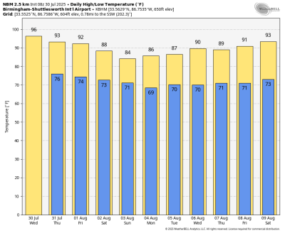
STILL HOT TODAY: Most Alabama communities will see a high in the mid 90s today with a partly sunny sky and the usual risk of a passing shower or storm in scattered spots from about 1 until 10 p.m. The chance of any one spot seeing rain today is 30-40%.
After today, heat levels slowly fall, and coverage of scattered showers and storms will rise through the weekend. Highs will be in the low 90s Thursday and Friday, and by Saturday and Sunday most Alabama communities will see a high in the 80s. The probability of any neighborhood seeing rain daily is 50-70%; most (but not all) of showers will come from noon to midnight.
NEXT WEEK: Global models suggest temperatures will remain below average for the first half of the week, with highs between 85 and 90 degrees; low 90s are likely Thursday and Friday. Each day we will have the usual round of random, scattered, mostly afternoon and evening showers and thunderstorms.
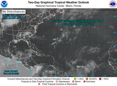
TROPICS: The Atlantic basin remains very calm, and tropical storm and hurricane formation is not expected for at least the next seven days. We are moving into the peak of the hurricane season — August, September and the first half of October.
ON THIS DATE IN 1979: A 40-minute hailstorm bombed Fort Collins, Colorado, with baseball- to softball-sized hail. Two thousand homes and 2,500 automobiles were damaged, and about 25 people were injured, mainly when hit on the head by the huge stones.
For more weather news and information from James Spann and his team, visit AlabamaWx.
Courtesy of AlabamaWx, the official weather blog of James Spann and his team, and Alabama News Center.